Map view
Copper Queen Mine Tour, Bisbee
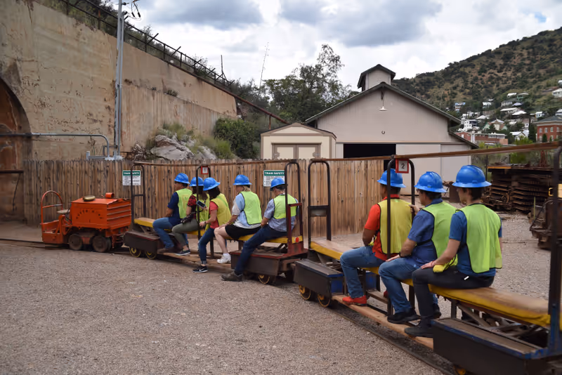
- The Copper Queen Mine was a copper mine in Cochise County, where its development led to the growth of the surrounding town of Bisbee in the 1880s
- Its orebody ran 23% copper, an extraordinarily high grade
- In in mid-1970s, with decreasing returns, the mining was ceased
- In 1976 the mine was reopened as a tourist attraction, where visitors today can embark on a guided tour into the mine
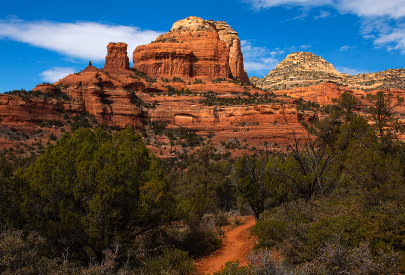
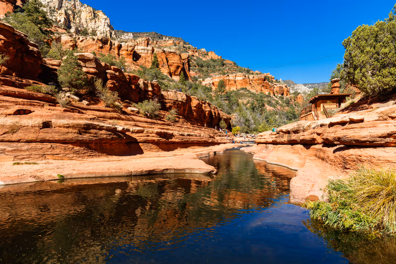
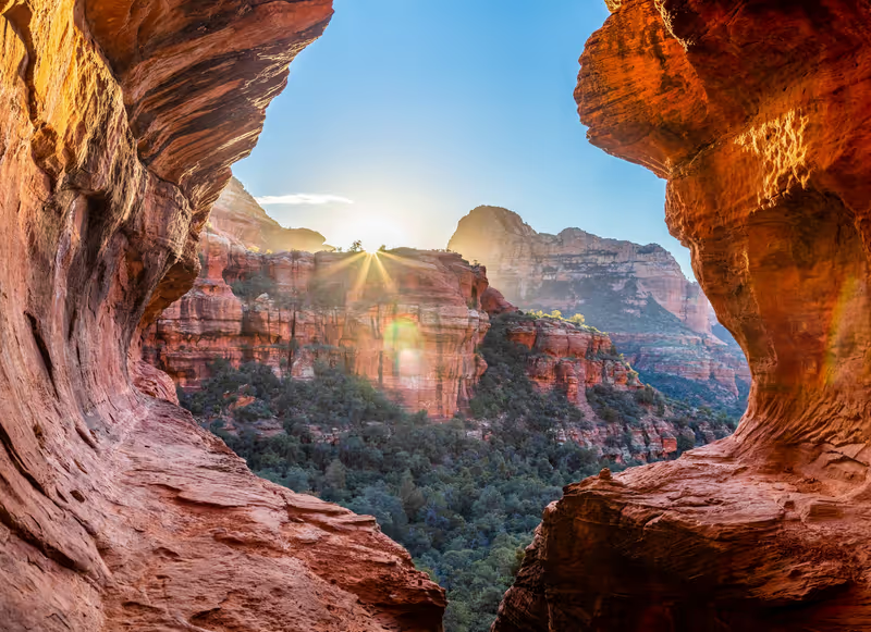
Seven Sacred Pools via Soldier Pass Trail, Coconino National Forest
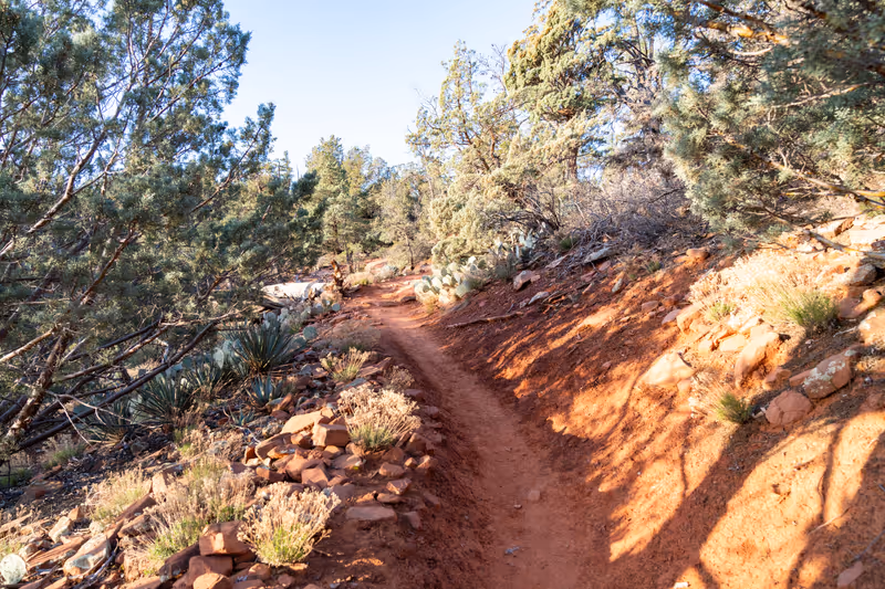
Walk difficulty: easy
- The Seven Sacred Pools are a series of small natural pools located along the Soldier Pass Trail near Sedona
- The area is known for its red rock formations and scenic views
Devil's Bridge Trail via Dry Creek Road, Coconino National Forest
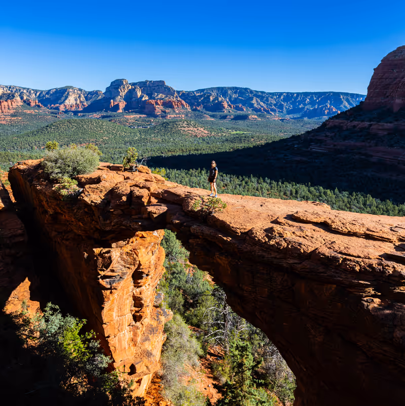
Walk difficulty: moderate
- Devil's Bridge Trail via Dry Creek Road is a hiking route located near Sedona
- The trail leads to Devil's Bridge, an iconic sandstone arch that offers views of the surrounding red rock formations, making it a favorite spot for photography
- The road leading to the trail is unpaved, and parking is limited, but the Sedona Shuttle is offered as an option to get to the trailhead
Devil's Bridge via Mescal Trailhead, Coconino National Forest
Walk difficulty: moderate
- Devil's Bridge via Mescal Trailhead is a hiking route located near Sedona
- The hike begins at the Mescal Trailhead, which provides access to the Chuck Wagon Trail, leading to Devil's Bridge
- The trail is known for its views of the surrounding red rock formations, making it a favorite among hikers and photographers
- Devil's Bridge itself is the largest natural sandstone arch in the Sedona area, offering a unique opportunity to walk across it
- Parking is limited, though a shuttle service offered
Seven Sacred Pools via Soldier Pass to Brins Mesa Loop, Coconino National Forest
Walk difficulty: moderate
- Seven Sacred Pools via Soldier Pass to Brins Mesa Loop is a scenic hiking trail located near Sedona, Arizona
- The trail offers views of Sedona's iconic red rock formations
- It includes notable sites such as the Seven Sacred Pools, which are natural pools formed in the rock
- Hikers can also explore Soldier Pass Caves along the trail
- Parking is limited, though a shuttle service offered
Seven Sacred Pools and Soldiers Pass Cave Trail, Coconino National Forest
Walk difficulty: moderate
- The Seven Sacred Pools and Soldiers Pass Cave Trail are hiking destinations located near Sedona, located within the Coconino National Forest
- The Seven Sacred Pools are a series of small, interconnected pools situated along the Soldiers Pass Trail
- These pools are formed by water collecting in depressions in the rock and can be particularly attractive after rainfall when they cascade into one another
- Parking is limited, though a shuttle service offered
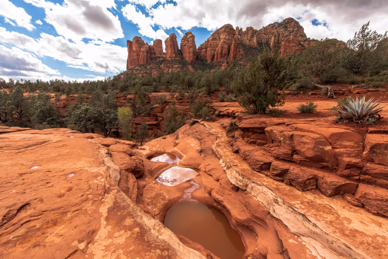
Cathedral Rock via Templeton Trail, Coconino National Forest
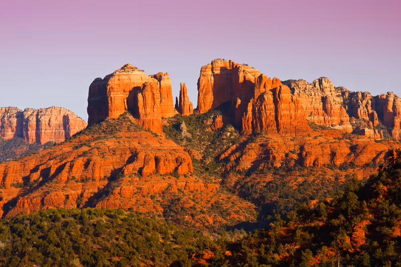
Walk difficulty: moderate
- Cathedral Rock is a sandstone butte located near Sedona
- The formation is characterized by its red rock formations, which are typical of the Sedona area
Bell Rock Trail, Coconino National Forest
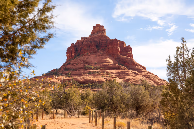
Walk difficulty: moderate
- The Bell Rock Trail, also known as the Bell Rock Pathway, is a hiking and biking trail located near Sedona
- The trail offers views of Bell Rock, Courthouse Butte, and the surrounding red rock landscape
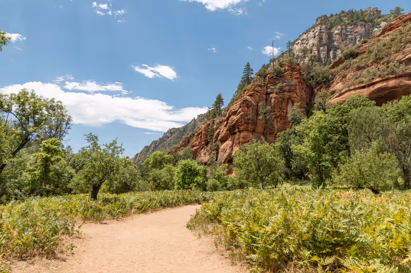
Oak Creek Canyon, Coconino National Forest
- Oak Creek Canyon is a river gorge that spans approximately 12 miles and features towering canyon walls
- The canyon is renowned for its scenery, characterized by colorful rock formations and lush forests
- The Oak Creek river flows year-round through the canyon, providing essential water for local flora and fauna
Sabino Canyon, Coronado National Forest
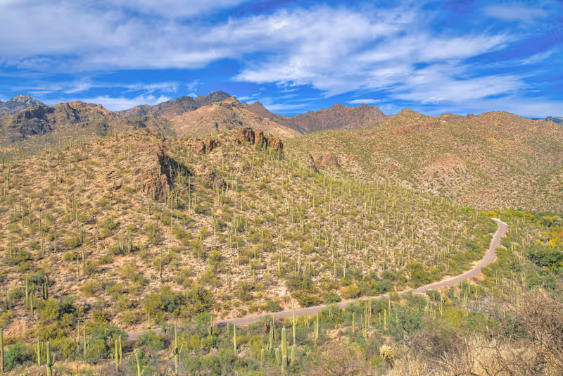
- Sabino Canyon is a prominent canyon situated in the Santa Catalina Mountains within the Coronado National Forest
- It serves as a destination for outdoor activities, offering various trails for hiking and sightseeing
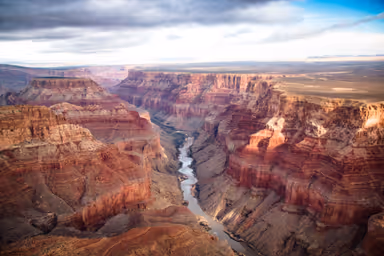
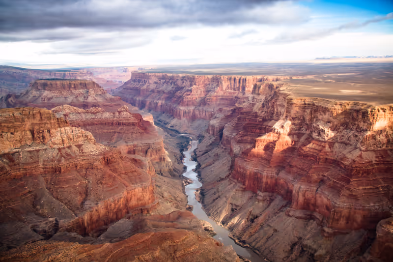
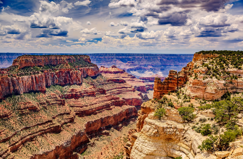
Grand Canyon South Rim, Grand Canyon National Park
Best time to visit: March-May, Sept-Nov
- Grand Canyon South Rim is the highway enters the park through the South Entrance, near Tusayan, Arizona, and heads eastward, leaving the park through the East Entrance
- It averages about 7,000 feet (approximately 2,134 meters) above sea level, providing stunning viewpoints
- The South Rim features Grand Canyon Village, which has campgrounds, lodges, restaurants, and visitor centers, and a shuttle system to help visitors navigate the area
- Overall, some 30 miles of the South Rim are accessible by road
Grand Canyon North Rim, Grand Canyon National Park
Best time to visit: March-May, Sept-Nov
- Grand Canyon North Rim is one of the two main rims of the Grand Canyon National Park, located in the northwest corner of Arizona
- The North Rim is situated at a higher elevation than the South Rim, ranging from approximately 8,000 to 8,800 feet above sea level
- Unlike the South Rim, the North Rim is less accessible and sees fewer visitors—only about 10% of all Grand Canyon visitors
- The area is known for its diverse wildlife and scenic overlooks, providing a more secluded experience compared to the busier South Rim
- The North Rim is typically open from mid-May to mid-October due to heavy snowfall in winter
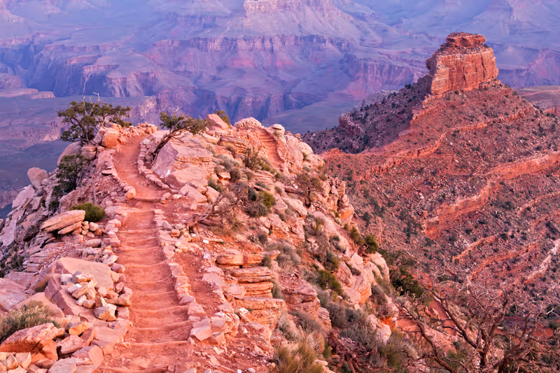
South Kaibab Trail to Cedar Ridge, Grand Canyon National Park
Walk difficulty: moderate
Best time to visit: March-May, Sept-Nov
- South Kaibab Trail to Cedar Ridge is a popular hiking route in the Grand Canyon National Park
- The trail offers expansive views of the canyon, and Cedar Ridge itself is a flat area perfect for resting and enjoying the scenery
- Due to limited parking at the trailhead, visitors are encouraged to use shuttle services
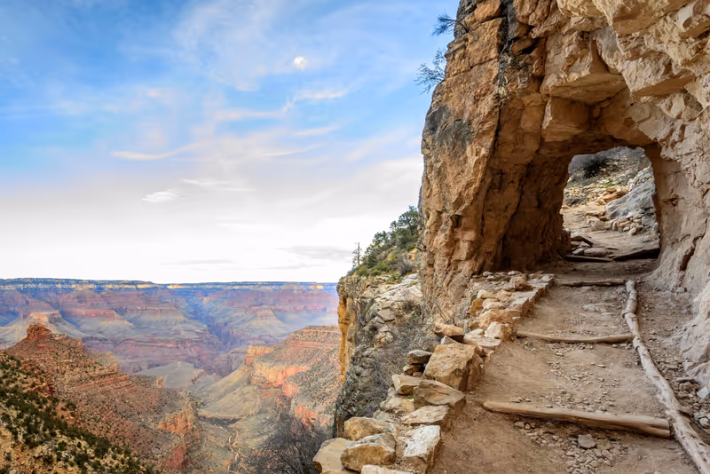
Rim Trail: Mather Point to Bright Angel Trailhead, Grand Canyon National Park
Walk difficulty: moderate
Best time to visit: March-May, Sept-Nov
- The Rim Trail: Mather Point to Bright Angel Trailhead is a hiking trail located in the Grand Canyon National Park
- The starting point is Mather Point, which is one of the most popular viewpoints in the Grand Canyon
- The ending point is Bright Angel Trailhead, a key access point for hikers descending into the canyon
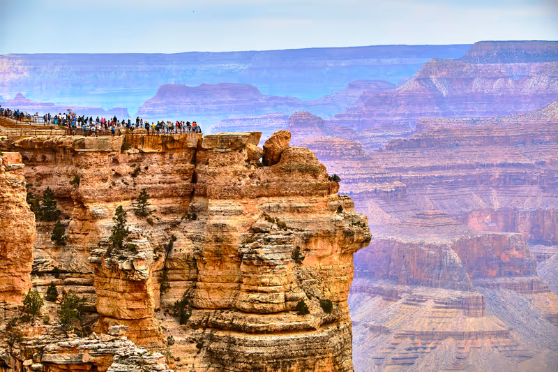
Mather Point, Grand Canyon National Park
Best time to visit: March-May, Sept-Nov
- Mather Point is a prominent viewpoint located in the Grand Canyon National Park
- The viewpoint stands at an elevation of 7,119 feet (2,170 meters) and is a popular first stop for many visitors to the canyon due to its views
South Kaibab Trail to Ooh Aah Point, Grand Canyon National Park
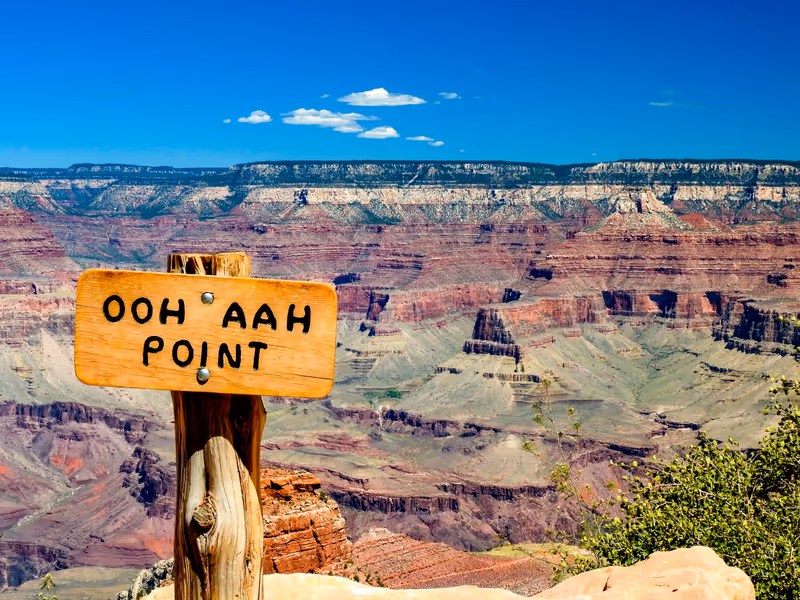
Walk difficulty: moderate
Best time to visit: March-May, Sept-Nov
- South Kaibab Trail to Ooh Aah Point is a hiking route located in the Grand Canyon National Park
- The trail offers spectacular views of the Grand Canyon
- It's named Ooh Aah Point because it is known for its breathtaking vistas, which often elicit an "ooh" or "aah" from visitors
Monument Valley
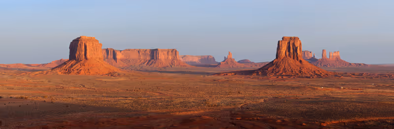
- Monument Valley is a region of the Colorado Plateau characterized by a cluster of sandstone buttes, with the largest reaching 1,000 ft (300 m) above the valley floor
- The most famous butte formations are located in northeastern Arizona along the Utah–Arizona state line
- Monument Valley has been featured in many forms of media since the 1930s, to symbolize the American West
- The valley is considered sacred by the Navajo Nation, the Native American people within whose reservation it lies
- Many visitors take guided tours from Navajo tour operators who take them down into the valley in Jeeps, who along the way, explain the rich history of the mythical formations
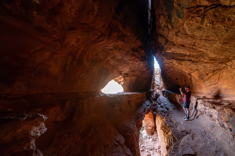
Upper Antelope Canyon, Navajo Nation
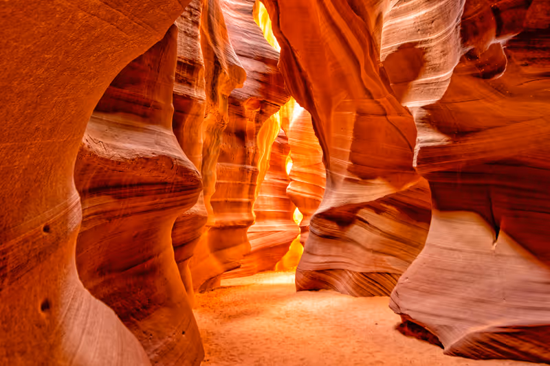
Walk difficulty: easy
- Navajo Upper Antelope Canyon is a slot canyon in the American Southwest, on Navajo land east of Lechee
- Antelope Canyon was formed by the erosion of Navajo Sandstone due to flash flooding and other sub-aerial processes
- Visitors will observe direct sunlight radiating down from openings at the top of the canyon, which make the inside canyon very colorful
- It is the primary attraction of Lake Powell Navajo Tribal Park
- Antelope Canyon is visited exclusively through guided tours, in part because rains during monsoon season can quickly flood it
Slide Rock State Park, Oak Creek Canyon
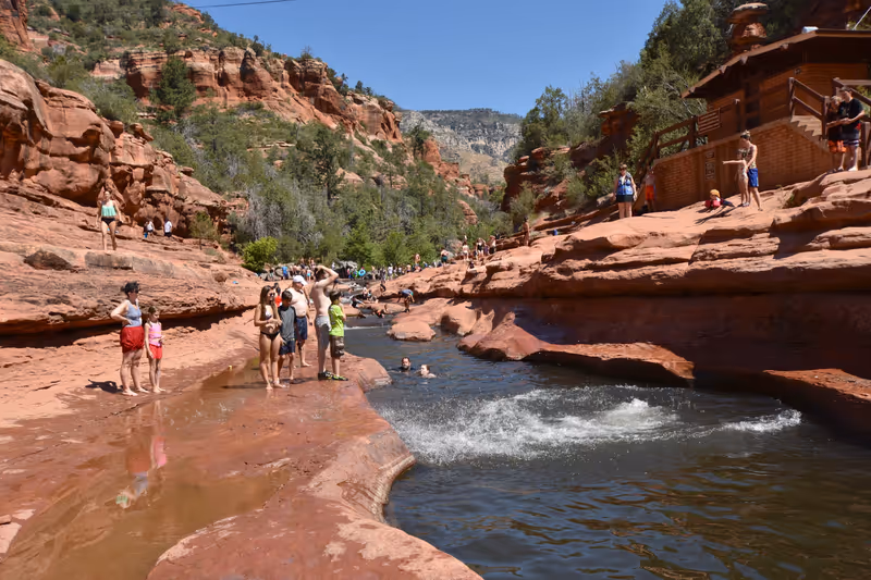
- Slide Rock State Park is a scenic park located in Oak Creek Canyon, established in the early 20th century
- The park features a historic apple farm that remains operational today
- The park is renowned for its natural water slide formed by an 80-foot stretch of Oak Creek, where visitors can slide down smooth, slick rocks into cold pools
- The surrounding area is characterized by stunning red rock formations typical of the region
Horseshoe Bend Trail, Page
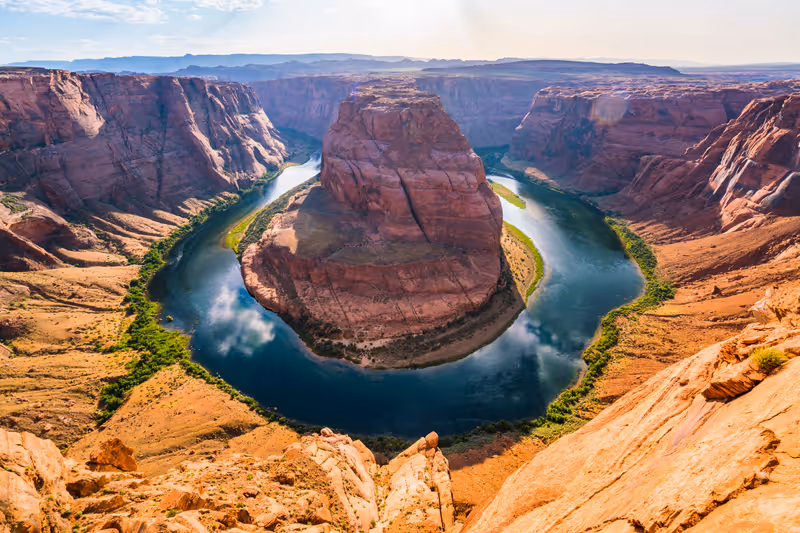
Walk difficulty: easy
- Horseshoe Bend Trail is a hiking route located near Page, within the Glen Canyon National Recreation Area
- This trail leads to a stunning overlook of the Horseshoe Bend, a dramatic meander of the Colorado River characterized by its horseshoe shape and surrounded by towering canyon walls
- The Colorado River can be seen as it curves around a rock formation that rises about 1,000 feet above the water
#45 in Best Attractions in the USA
Painted Desert, Petrified Forest National Park
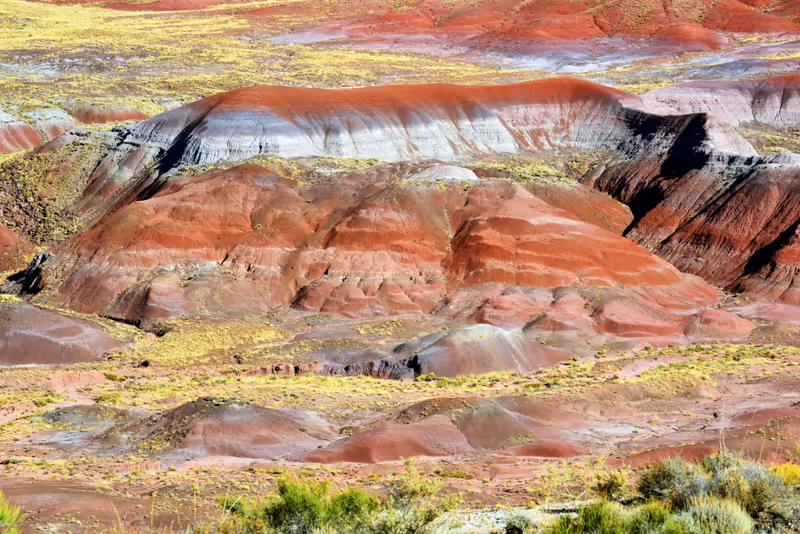
Walk difficulty: easy
- The Painted Desert is a United States desert of badlands in the Four Corners area, running from near the east end of Grand Canyon National Park and southeast into Petrified Forest National Park
- The Painted Desert is known for its brilliant and varied colors, which include the more common red rock, but also shades of lavender
- The colorful rock results from the erosion of sedimentary rock formations such as siltstone and mudstone
- An assortment of fossilized prehistoric plants and animals are found in the region, as well as ancient dinosaur tracks and evidence of early human habitation
Desert Botanical Garden, Phoenix
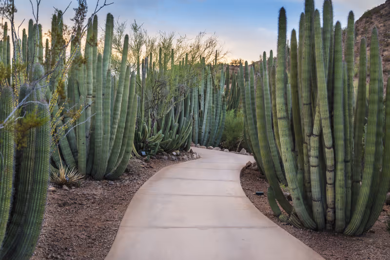
Best time to visit: Jan-April, Nov-Dec
- Desert Botanical Garden located in Papago Park, in Phoenix
- Founded in 1937, the garden now has more than 50,000 plants in more than 4,000 taxa, one-third of which are native to the area, including 379 species which are rare, threatened or endangered
- The garden focuses on plants adapted to desert conditions, including an Australian collection, a Baja California collection and a South American collection
Musical Instrument Museum, Phoenix

Best time to visit: Jan-April, Nov-Dec
- The Musical Instrument Museum is located in Phoenix, and was opened in 2010
- It is the largest museum of its type in the world
- The collection of over 15,000 musical instruments and associated objects includes examples from nearly 200 countries and territories, representing every inhabited continent
- Some larger countries such as the United States, Mexico, India, China, and Brazil have multiple displays with subsections for different types of ethnic, folk, and tribal music
#40 in Best Museums in the USA
Camelback Mountain, Phoenix
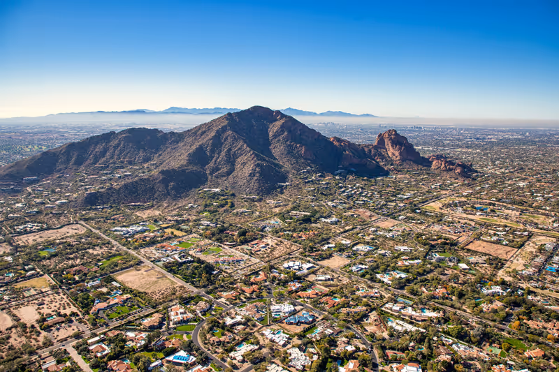
Best time to visit: Jan-April, Nov-Dec
- Camelback Mountain is a prominent mountain located in Phoenix, known for its distinctive shape that resembles the hump and head of a kneeling camel
- The mountain is a popular destination for hiking and outdoor activities, where it features two main trails: the Echo Canyon Trail and the Cholla Trail
- Camelback Mountain is notable for its geological features, including a unique unconformity between two different rock formations
- Its silhouette is a defining characteristic of the Phoenix skyline
Boynton Canyon Trail, Red Rock-Secret Mountain Wilderness
Walk difficulty: moderate
- Boynton Canyon Trail is a hiking trail located near Sedona
- Hikers can visit views of the canyon floor, lush forests, and unique rock formations
- The area is rich in wildlife and provides a backdrop of the surrounding desert landscape
- The trail includes ancient Sinaguan Indian ruins, the Subway Cave and a box canyon that sometimes features a small waterfall
West Fork of Oak Creek Trail #108, Red Rock-Secret Mountain Wilderness
Walk difficulty: moderate
- The West Fork of Oak Creek Trail #108 is a hiking trail located near Sedona, Arizona, within the Coconino National Forest
- The trail features views of a deep, narrow gorge with lush riparian environments, especially attractive during autumn when the foliage changes
Wasson Peak via Kings Canyon, Hugh Norris, and Gould Mine, Saguaro National Park
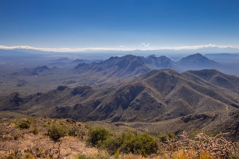
Walk difficulty: moderate
- Wasson Peak is the highest point in the Tucson Mountains and is located within Saguaro National Park
- The hike to Wasson Peak via the King Canyon, Hugh Norris, and Gould Mine trails offers views of the surrounding landscape, including the saguaro cacti that populate the area
- As the highest peak in the Tucson Mountains, Wasson Peak offers panoramic views of Saguaro National Park and the city of Tucson
Old Town Scottsdale

- Old Town Scottsdale is a historic district located in downtown Scottsdale
- The area retains an old western town feel, showcasing the history of the American Southwest
- Old Town is home to over 400 retail shops and 120 restaurants, where visitors can find souvenirs, art, and jewelry with a Southwestern flair
- Old Town is known for its wine tasting rooms, featuring offerings from several award-winning Arizona wineries
- The area is organized into nine walkable and bikeable districts, making it easy for visitors to explore on foot or by bike
Taliesin West, Scottsdale
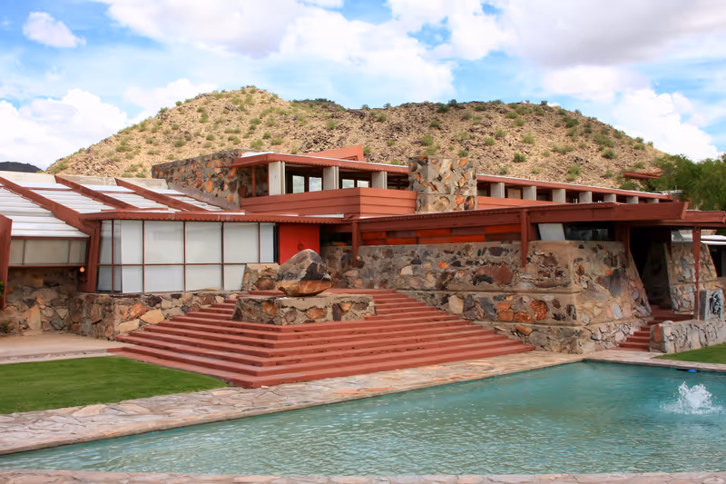
- Taliesin West is a significant architectural site located in the desert foothills of the McDowell Mountains in Scottsdale
- It was designed and built by the renowned American architect Frank Lloyd Wright as his winter home and studio
- Established in the 1930s, Taliesin West served as a laboratory for Wright's architectural ideas and practices
Chapel of the Holy Cross, Sedona
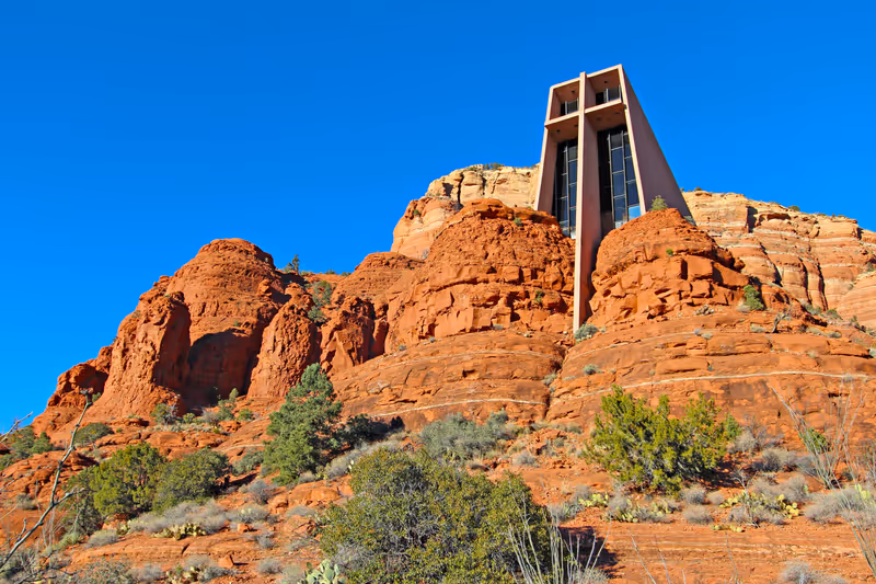
Best time to visit: March-May
- The Chapel of the Holy Cross is a Roman Catholic chapel located in Sedona, Arizona, renowned for its architecture and views
- The chapel is built into the red rock buttes of Sedona, specifically within the Coconino National Forest, and is situated between two natural stone spires
- the chapel was inspired by the Empire State Building and constructed between 1954 and 1956
Island Trail and Walnut Canyon Trail Loop, Walnut Canyon National Monument
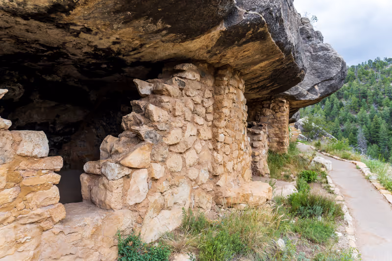
Walk difficulty: moderate
- The Island Trail and Walnut Canyon Trail Loop are hiking routes located in Walnut Canyon National Monument
- Island Trail descends into Walnut Canyon, allowing hikers to view a series of ancient cliff dwellings that were part of a pueblo community thriving around 700 years ago
- Walnut Canyon Trail Loop travels clockwise around a rocky butte known as the Island, which was formed by a meander of Walnut Creek